ARTICLE AD BOX
By Elna Schutz
Business reporter
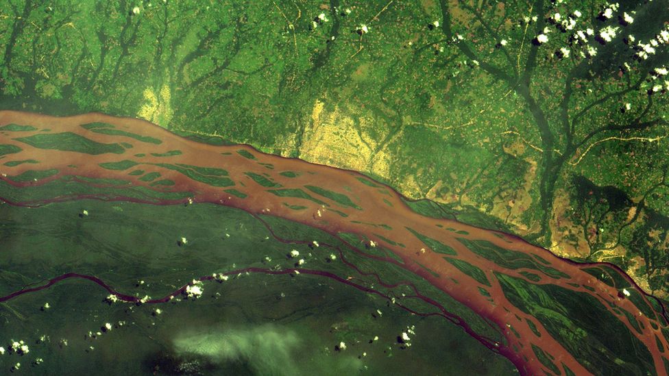 Image source, FAO
The Congo river and surrounding forests
Conservationist, Leonidas Nzigiyimpa says "you can't manage what you don't know".
He adds: "In order to improve the situation of forests, we need to use new technology."
Mr Nzigiyimpa is the chief warden of five protected forestry areas in the small central African country of Burundi.
For the past two decades, he and his team have been working with local communities to protect and manage the forest. His face lights up when he describes the fresh smell and beauty of the areas. "It's pure nature," he says.
In carrying out his work, Mr Nzigiyimpa has to consider a range of factors, from monitoring the impact of human actions and economies, to tracking biodiversity and the impact of climate change, plus staff numbers and budgets.
Image source, Elna Schutz
Image caption,Conservationist Leonidas Nzigiyimpa has won international awards for his work
To help him track and record all of this, he now uses the latest version of a free piece of software called the Integrated Management Effectiveness Tool.
The tool was developed specifically for such environmental work by a project called Biopama (Biodiversity and Protected Areas Management Programme). This is supported by both the European Union and the 79 member state Organisation of African, Caribbean and Pacific States.
"So, we use this kind of tool to train the managers of the site to use it to collect good data, and to analyse this data, in order to take good decisions," says Mr Nzigiyimpa.
Tracking and protecting the world's forests is not just important for the local communities and economies most directly affected. Deforestation contributes to climate change so restoring forests could help combat it.
Some 10 million hectares (25 million acres) of the world's forests are lost every year, according to the United Nations.
To try to restore forests and other natural habitats around the world, the United Nations last year launched the UN Decade on Ecosystem Restoration. This has seen countries, companies and other organisations promise action towards preventing, halting and reversing the degradation of ecosystems worldwide.
"But just saying that we're going to restore, it's not enough," says Yelena Finegold, forestry officer at the Food and Agricultural Organization (FAO) of the United Nations. "There's the need for responsible planning of how that ecosystem restoration is going to happen, followed by actions on the ground enabled by investments in restoration, and monitoring systems in place to track that ecosystem restoration."
Image source, Yelena Finegold
Image caption,Yelena Finegold says the aim is to both track deforestation - and to reverse it
This increased focus on managing forests has given rise to new digital tools to gather, sort and use data better.
One of these is the FAO's own Framework for Ecosystem Monitoring (Ferm) website. The site was launched last year, and uses satellite imagery to highlight changes to forests around the world. The maps and data are accessible to any internet users, be they a scientist, government official, business, or member of the public.
A key data source for Ferm is US space agency Nasa, and its Global Ecosystem Dynamics Investigation system. Known as Gedi for short, this acronym is pronounced like the word Jedi from the Star Wars films. And continuing the theme of that movie series, its tagline is "may the forest be with you".
The tech itself is certainly very sci-fi turned real life. "We shoot laser beams at trees from the International Space Station," says Laura Duncanson, who helps to lead the Gedi project from the Univesrity of Marylands's Department of Geographical Sciences.
Image source, Getty Images
Image caption,Nasa's Gedi system fires laser beams from the International Space Station
"We use the use the reflected energy to map forests in 3D, including their height, canopy density, and carbon content," adds Dr Duncanson, who is a leading expert in remote sensing. "This is an exciting new technology because for decades we have been able to observe deforestation from space, but now with Gedi we can assign the carbon emissions associated with forest loss [for greater accuracy]."
Maps and data are also provided to Ferm by Norwegian business Planet Labs, which operates more than 200 camera-equipped satellites. These take some 350 million photos of Earth's surface on a daily basis, each covering an area of one sq km.
Image source, Ferm
Image caption,The Ferm website is accessible by everyone
Planet Labs can also be directly hired by governments and businesses around the world. In addition to monitoring forests, its cameras can be used to check everything from droughts to agriculture, energy and infrastructure projects, and monitoring key infrastructure, such as ports.
Remi D'Annunzio, a fellow FAO forestry officer, says that all the available imagery from space "has tremendously changed the way we monitor forests, because it has produced extremely repeatable observations and extremely frequent revisits of places".
He adds: "Basically, now, with all these publicly available satellites combined, we can get a full snapshot of the Earth every four to five days."
Image source, FAO
Image caption,Rangers in Vietnam are now using data from Ferm to tackle illegal logging
Examples of how all this near real-time monitoring via Ferm is now being used are pilot schemes in Vietnam and Laos that are trying to tackle illegal logging. Rangers and community workers on the ground are sent alerts to their mobile phones when new deforestation is spotted.
"Now, what we're really trying to do is not just understand the volume of forests being lost, but where is it specifically being lost in this district or that, so that we can monitor loss, and even prevent it in near real-time, from getting worse," says FAO forestry officer, Akiko Inoguchi.

 2 years ago
54




 English (US) ·