ARTICLE AD BOX
 Image source, Courtesy Canadian Space Agency
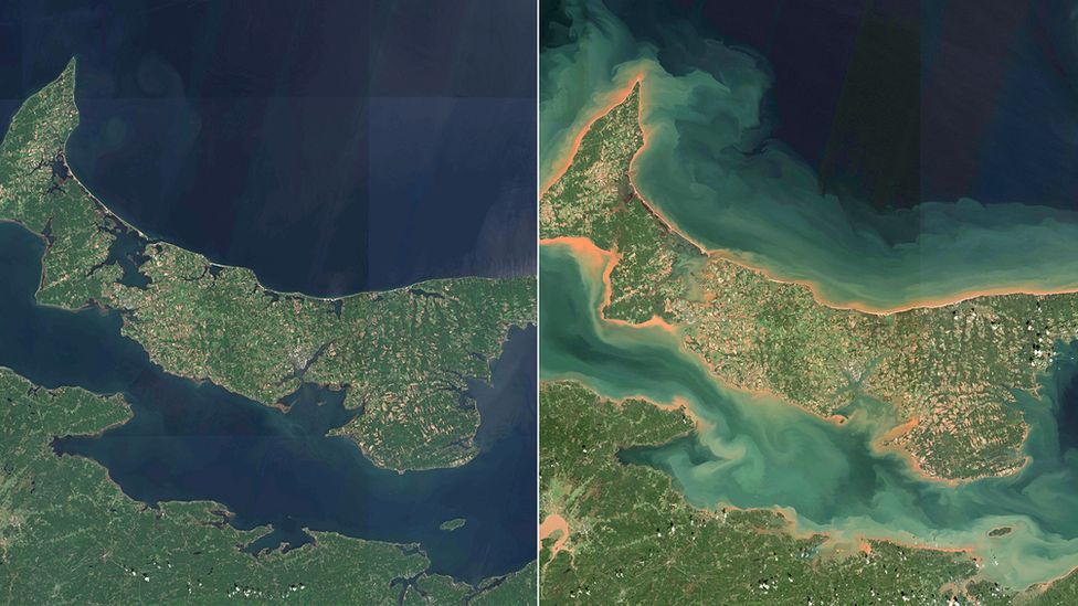
The space agency released a comparison image of PEI and the Northumberland Strait, taken in August and on 25 September
Pictures reveal the devastating damage that Storm Fiona has caused in eastern Canada's coastal communities.
The "historic" storm touched parts of five provinces over the weekend, bringing with it torrential rain and hurricane-force winds of up to 160km/h (100mph).
The Canadian Space Agency has released satellite images showing the devastation that Storm Fiona brought to Canada's eastern seashore.
The before-and-after picture of the Northumberland Straight - the body of water that divides the island province of Prince Edward Island (PEI) from the mainland province of New Brunswick - shows massive coastal erosion.
Veterans Affairs Minister Lawrence MacAuly, who is from the province, called into a press conference on Fiona recovery efforts by phone on Wednesday as power and internet were still down in his region.
He said he could "see the destruction that Fiona has brought to our homes, wharfs and barns".
"The destruction across Prince Edward Island is truly unreal."
In Thunder Cove, on the northern shore of PEI, a popular landmark has been destroyed.
The Teacup - a rock formation that resembled an old-fashioned cup and saucer - has toppled into the sea. PEI local Marg Chisholm-Ramsey snapped a photo of the rock the afternoon before the storm landed, and the day after it cleared.
Image source, Marg Chisholm-Ramsay/Facebook
Image caption,Prince Edward Island's Teacup in Thunder Cove before and after Hurricane Fiona came through
"She was a soothing rock, a magnificent one that came out of the ocean meters from where any rock should be. You'd always hear the ocean's gentle roar in her background," she wrote on Facebook.
"She meant a lot to so many and now she's gone. Her soothing presence is no longer. Her bits now spread on the shore and in the ocean."
The army has been deployed to Nova Scotia, Newfoundland and Labrador and PEI to assist the clean-up, conduct wellness checks and restore the power grid. Thousands of people are still without power. At least two people died in the storm, and one person remains missing.
Prime Minister Justin Trudeau is also visiting some of the worst hit areas - he visited PEI and Cape Breton in Nova Scotia on Tuesday, and is expected to visit Port Aux Basque in Newfoundland on Wednesday.
Image source, Reuters
Image caption,Port aux Basques, home to only 4,000 people, was one of the worst hit areas
"The reality is that extreme weather events are going to get more intense over the coming years because our climate is changing. That's why we have to make sure we're adapting to it," he said.
Port aux Basques, a small town on the southwestern tip of Newfoundland, is one of the areas with the most widespread damage.
At least 76 homes in the community of 4,000 people were structurally damaged or completely destroyed by the storm.
The credit agency DBRS Morningstar estimated that Fiona will cause C$300m ($220m; £202m) to C$700m in insured losses in Atlantic Canada.
The Canadian Red Cross has set up a national fundraiser to assist, and the federal government will be matching donations for the next 30 days.

 2 years ago
62


 English (US) ·